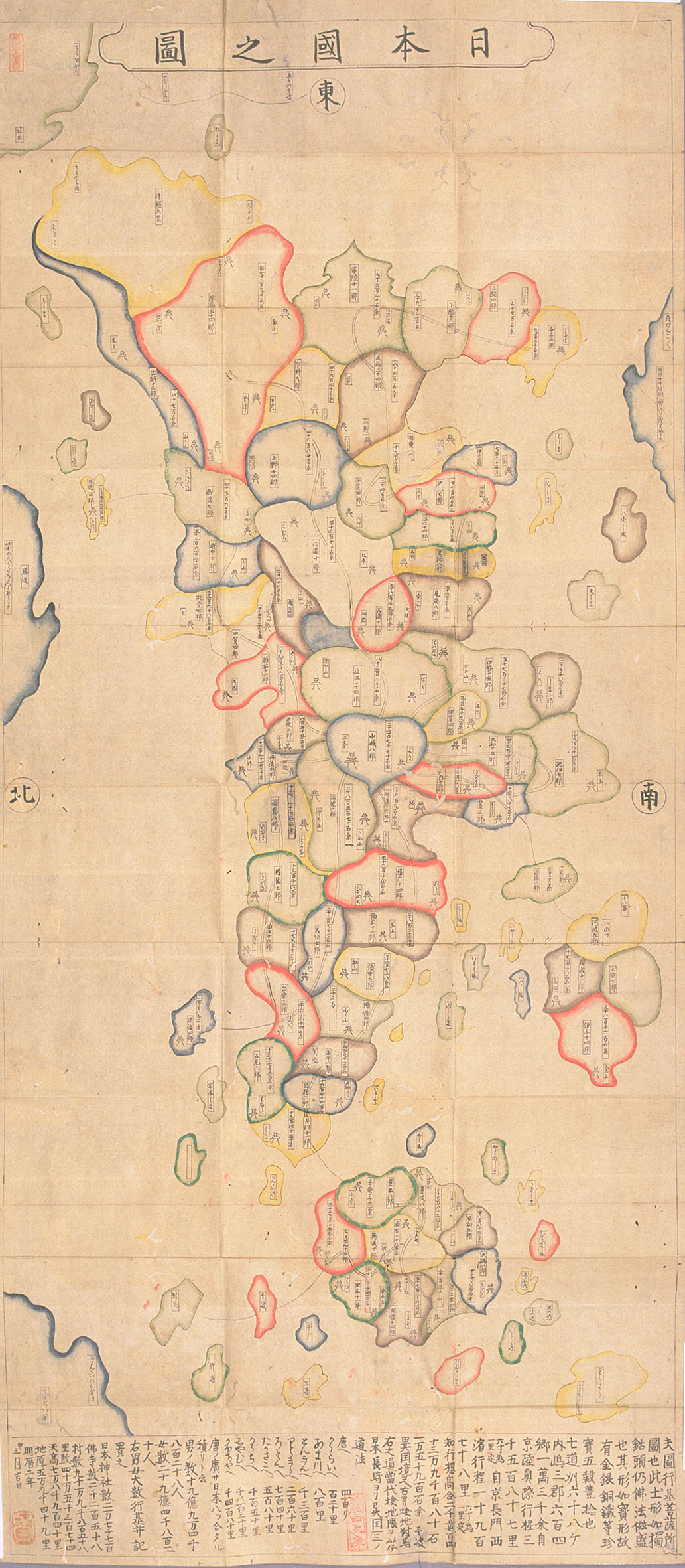
‘Map of Japan’ (Nihon koku no zu 日本國の圖), Gyōki map, calligrahy, colours, ca. 1656 (Meireki 2), Meiji University Library, Ashida Map Collection, URL: http://www.lib.meiji.ac.jp/perl/exhibit/ex_search_detail?detail_sea_param=9,105,0,b
A map type, reflecting the birth of the ancient Japanese state, is the so-called ‘Gyōki map’ (Gyōki-zu 行基図). Gyōki maps can be regarded as the visualization of the sum of information, which the imperial court collected from the provinces. As a special feature, these maps, said to have been initiated by the priest and engineer Gyōki (668–749), show the provinces of Japan in round and oval shapes, clustered to each other like fish scales, and the highways, leading to Yamashiro province with the imperial capital Kyoto since 794. Though the ‘Revised map of the world’ (Kaisei yochizu 改正輿地図) of 805 is considered the oldest example, the extant copy, held by Kamomioya Shrine in Kyoto, dates from the Edo period. The earliest original Gyōki map is in the property of the Ninna-ji in Kyoto, and dates from 1305. It has a south orientation, implying that Mutsu Province, taking up the eastern tip of Honshū, appears to the left of the map. To the west, the map reaches until Bingo on Honshū and Sanuki on Shikoku. The further part of the map is missing. A further Gyōki map from the same period, held at the Kanazawa Bunko, shows Japan clasped by a dragon. The tail and head of the dragen as well as the eastern part of Japan are missing on the remaining fragment.
A ‘map of Japan’ (Nihon-koku no zu) is thought to be a copy of a printed Gyōki map, published in 1656 (Meireki 2), and has the caption: ‘This is a map of Gyōki Bodhisattva.’ Following older Gyoki maps, it shows mythical countries: the ‘country of [female] demons’ (Rasenkoku, also Rasetsukoku) to the south of Awa Province (present-day Chiba Prefecture) and Gandō (also Kari no michi, lit., ‘route of the wild geese’) to the north of Etchū Province (present-day Toyama Prefecture). But the map also includes then recent information. First, it shows Edo-period daimyo castles. Second, the map indicates the value of provinces in koku 石 (unit of volume to measure rice) in accordance with the taxation system in the Edo period. Finally, though the maps is inaccurate, by showing a compressed Tōhoku area and exagerating the size of the inland sea and of smaller islands off the Japanese coast, it shows Korea (Kōrai-koku) in the west (low left corner) and Hokkaido in the north-east (top left corner). The latter island is missing in earlier Gyōki maps. Whereas in Japan Gyōki maps came to serve as decoration on objects, such as fans, mirrors and pottery, during the Edo period, in Europe they were one of the only sources of information about the geography of Japan in the sixteenth century.

